
Looking good. Is there any way to indicate what type of chargers are in a collected blob? Perhaps with the outer ring colour? If I see that I have 4 possible 7kW chargers in range, and a rapid charger that I may just reach... it would help to know that the group of 4 chargers in one blob on a slightly different route also includes a rapid charger. Matt On 16 April 2013 14:32, Kevin Sharpe ZCW <kevin.sharpe@zerocarbonworld.org>wrote:
Just a brief update to show progress is being made with the OCM integration :-)
Kevin Sharpe | Founder & Patron Tel: +44 122 566 7544 ext: 800 | Skype: zerocarbonworld kevin.sharpe@zerocarbonworld.org <kevin.sharpe@zerocarbonworld.org>| www.zerocarbonworld.org | twitter.com/zerocarbonworld<http://twitter.com/ZCWcharlie> Zero Carbon World is a UK Registered Charity #1141347 From: Mark Webb-Johnson <mark@webb-johnson.net> Reply-To: OVMS Developers <ovmsdev@lists.teslaclub.hk> Date: Wednesday, 6 March 2013 08:41 To: OVMS Developers <ovmsdev@lists.teslaclub.hk>
Subject: Re: [Ovmsdev] Seeking ideas for 'range' representation
Nikolay,
Seems a very similar approach:
But, we would only show chargepoints in range.
Regarding using OCM, quite frankly they are sponsoring this work and I'm happy to accept. Their database is pretty extensive and global and their 'open' philosophy suits as well. The entire OVMS project (apps, server, car module software and hardware) is open source, and on github - so it is free for anyone to do with as they want.
Regarding the use of intents and reversing this so that the other apps do the displays, while I agree that technically that is an elegant solution, it is really beyond the scope of what we can control. We can pull free and open databases of information into OVMS, but we can't make other systems to pull data from or otherwise integrate with our intents. We could try persuasion, but I don't have high hopes to get 20+ vendors to accept our approach. Technically, on iOS, this is also a nightmare - applications are sandboxed and inter-app communication is almost impossible (and promptly shut down by Apple whenever possible). The only thing iOS has is the URL scheme.
In fact, essentially the same situation as OpenChargeMap in general. They can have a completely open database that anyone can contribute to and download. But, they can't force people to use it.
I would love a generic framework, but that is really beyond the resources we have at the moment. Even then it would be a nightmare to remove duplicates if more than one source was plugged in.
{soapbox}The whole situation with proprietary charge location databases is a nightmare, and very detrimental to the EV movement. If the charging stations can be used by anyone, why can't their location? I really hope that databases like OpenChargeMap can go some way to forcing the openness of this.{/soapbox}
Regards, Mark.
On 6 Mar, 2013, at 2:59 PM, Nikolay Shishkov wrote:
Some examples:
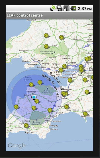
Here is an example of a range calculation and visualization I made: https://play.google.com/store/apps/details?id=com.nikpix.LeafRangeCalc
And here is the integration of openchargemap I wrote in my previous e-mail:
https://play.google.com/store/apps/details?id=com.applications.lawsystems.le...
Here is a screenshot of the range visualization:
https://lh4.ggpht.com/D4dD0xdgJI8CEMAwhPa0sPp9zzsNf_j4SQksFTfZlowVdj9YfU6EFh...
Nikolay
________________________________ From: Nikolay Shishkov <nshishkov@yahoo.com> To: OVMS Developers <ovmsdev@lists.teslaclub.hk> Sent: Wednesday, March 6, 2013 7:53 AM Subject: Re: [Ovmsdev] Seeking ideas for 'range' representation
Mark,
Display of range can be done in a similar way openchargemap was integrated in one of the nissan leaf apps out there - some of their guys can probably show you. I think it was concentric circles.
Integration of a particular database of charging stations is a mistake - there are at least 20 such out there. On android this could be done much more elegantly by intents - we can have a "visualize range on map" intent (with parameters like - max range, kWh available, weight of car, efficiency) and have different apps implement that intent and create visualization based on the input data. This would be similar in the way the contacts app in your android phone can dial a phone number with the phone app via dialing intent. I am not sure how would this best be done in the IOS world.
Note that I am partial - I am the founder of www.uppladdning.nu a database/mapping on charging sites solution for the nordic region and have had some dealings with the openchargemap before.
Nikolay
________________________________ From: Mark Webb-Johnson <mark@webb-johnson.net> To: OVMS Developers <ovmsdev@lists.teslaclub.hk> Sent: Wednesday, March 6, 2013 2:12 AM Subject: Re: [Ovmsdev] Seeking ideas for 'range' representation
Felix,
Yes, I agree. This is really not something that can ever be 100% - we just want something to represent roughly what is possible and to limit the charge stations that we show.
A nice thing about circles is that it easy to visually estimate 50% (or whatever), so I think the user can do this themselves.
Perhaps the existing outer estimated-to-ideal circle at 50% transparency, then an inner estimated-to-N%estimated circle at 25% transparency? Or is that too complex?
We're also planning to have a feature of show-route-to-charging-station, for a particular selected charging station, and that will be google maps / whatever so will show real distance by road.
Regards, Mark.
On 6 Mar, 2013, at 9:03 AM, felix bonnier wrote:
Hi Mark,
The only thing with this is, obviously roads are not straight so a radius will never show a correct estimate. I think the range estimate would have to
be only a percentage of the two values so that the range circle would be more realistic….. Maybe 60% of the values given by the car or something to that effect. Otherwise you will never make it to the next charge point………. what do you think?
felix b.
On Mar 6, 2013, at 8:46 AM, Mark Webb-Johnson <mark@webb-johnson.net> wrote:
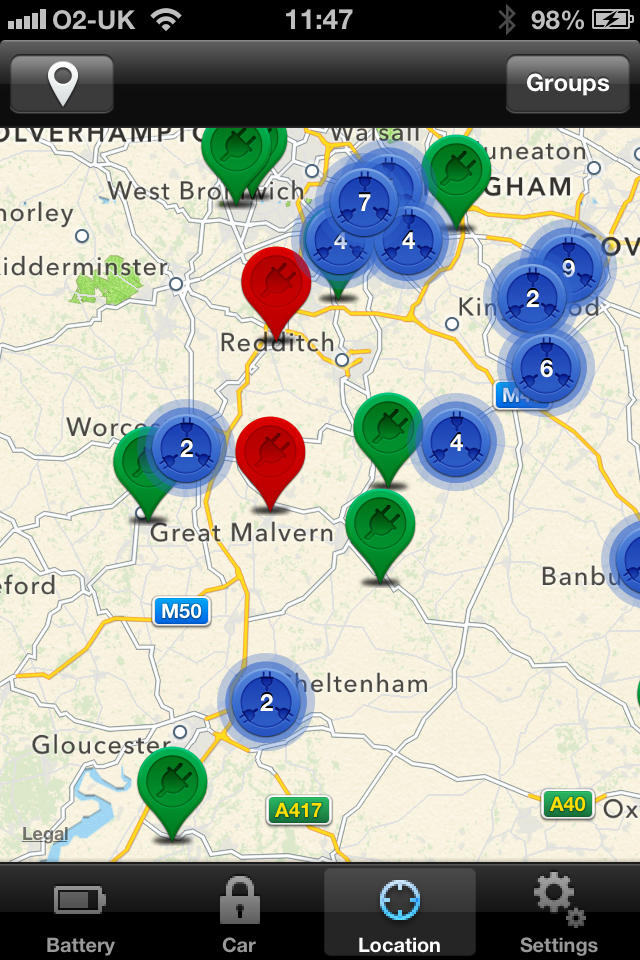
Working with the guys at zerocarbonworld / openchargemap on the integration of Open Charge Map to the OVMS Apps, we are trying to find a way to represent range graphically.
The first idea was a circle, centered around the car, with the inner edge of the circle being estimated range and the outer edge ideal range (or vice versa if you are coming down the mountains on a _long_ mountain road). Plugging in the values for my car today,
assuming I was somewhere in the centre of the UK, it would look something like this:
<PastedGraphic-4.png>
The idea is to represent the range, and then plot the charge points within (and perhaps also slightly outside) that range.
That is just one idea. What do people think? Any other suggestions?
Regards, Mark.
P.S. Work on the Apps for this has already started, so I would appreciate a quick reply. Nothing too extensive - just ideas.Thanks.
_______________________________________________
OvmsDev mailing list
OvmsDev@lists.teslaclub.hk
http://lists.teslaclub.hk/mailman/listinfo/ovmsdev
_______________________________________________
OvmsDev mailing
list
OvmsDev@lists.teslaclub.hk
http://lists.teslaclub.hk/mailman/listinfo/ovmsdev
_______________________________________________ OvmsDev mailing list OvmsDev@lists.teslaclub.hk http://lists.teslaclub.hk/mailman/listinfo/ovmsdev
_______________________________________________ OvmsDev mailing list OvmsDev@lists.teslaclub.hk http://lists.teslaclub.hk/mailman/listinfo/ovmsdev _______________________________________________ OvmsDev mailing list OvmsDev@lists.teslaclub.hk http://lists.teslaclub.hk/mailman/listinfo/ovmsdev
_______________________________________________ OvmsDev mailing list OvmsDev@lists.teslaclub.hk http://lists.teslaclub.hk/mailman/listinfo/ovmsdev